geocat.ch
Statistica della superficie per la Svizzera
Die Arealstatistik liefert detaillierte und genaue Informationen über den Zustand und die Entwicklung der Bodennutzung und Bodenbedeckung in der Schweiz. Auf dieser Seite finden Sie die Geodaten der Arealstatistik in Hektarauflösung seit 1979, sowie Informationen über die Grundlagen und Methode zur Erstellung dieser Daten.
Simple
Informazioni di identificazione
- Titolo alternativo
-
Statistica della superficie
- Data (Revisione)
- 2023-08-30
- Identificatore
- ch.bfs.arealstatistik
Identificatore
- Titolo collettivo
-
Statistica della superficie della Svizzera
- Finalità
-
Detaillierte Erhebung der Bodennutzung und -bedeckung der Schweiz mit dem Ziel, deren Zustand und Entwicklung periodisch auszuweisen.
- Status
- In corso
Punto di contatto
Servizio responsabile
- Nome dell'ente
-
BFS/OFS GEOSTAT
- Ruolo del responsabile
-
GEOSTAT ist das BFS-Kompetenzzentrum für Geoinformation und digitale Bildverarbeitung.
Indirizzo
- Città
-
Neuchâtel
- Codice postale
-
2010
- Nazione
-
CH
-
geostat@bfs.adm geostat@bfs.admin.ch
- Via
-
Espace de l'Europe
- Numero
-
10
- Casella postale
-
2010
- Risorsa online
- https://www.bfs.admin.ch/bfs/de/home/dienstleistungen/geostat.html ( WWW:LINK )
- Ruolo
- Point of contact
- Frequenza di aggiornamento
- Secondo necessità
-
GEMET - INSPIRE themes, version 1.0
-
-
Utilizzo del territorio
-
Copertura del suolo
-
-
GEMET
-
-
vegetazione
-
-
geocat.ch
-
-
IFDG Infrastruttura federale dei dati geografici
-
opendata.swiss
-
-
GEMET
-
-
fotografia aerea (immagine)
-
-
geocat.ch
-
-
opendata.swiss
-
- Limitazione d’uso
-
Freie Nutzung. Quellenangabe ist Pflicht.
- Vincoli di accesso
- Diritti di proprietà intellettuale
- Vincoli di fruibilità
- Altri vincoli
- Identificatore aggregato del dataset
- 2da61838-68bf-4a64-9d9f-05236cde1bf1
- Tipo di associazione
- Larger work citation
- Distanza
- 100 m
- Lingua dei metadati
- Deutsch
- Lingua dei metadati
- Français
- Lingua dei metadati
- Italiano
- Lingua dei metadati
- English
- Set dei caratteri dei metadati
- UTF8
- Tema
-
- A Carte di base, copertura del suolo, immagini aeree
- A1 Carte di base, modelli del territorio
- A2 Copertura e utilizzo del suolo
Estensione
- Descrizione
-
Svizzera
))

- Informazioni supplementari
-
Originalresultate aller neueren Arealstatistiken werden bei GEOSTAT in relationalen Datenbanken verwaltet, in welchen jeder Stichprobenpunkt (die für jeden Erhebungszeitpunkt identisch sind) einen Datenrecord darstellt. Für die Diffusion können daraus gleichermassen strukturierte Textdateien (Normalfall), bei Bedarf aber auch GIS-kompatible Vektor- (Punktdaten) oder Rasterdaten (GRID, GeoTIFF) erzeugt werden.
- Identificatore del geodato di base
-
12.3
- Genere dell'identificatore
- Confederazione
- Formato di distribuzione
-
-
TEXT, semicolon separated (CSV)
()
-
TEXT, semicolon separated (CSV)
()
- Risorsa online
- Previsione map.geo.admin.ch ( MAP:Preview )
- Risorsa online
- Geodaten (csv) ( WWW:DOWNLOAD-URL )
- Risorsa online
- Variablenliste ( WWW:DOWNLOAD:TEXT, semicolon separated (CSV) )
- Risorsa online
-
ch.bfs.arealstatistik-bodenbedeckung
(
OGC:WMS
)
Servizio WMS-IFDG, strato "Statistica della superficie copertura"
- Risorsa online
-
ch.bfs.arealstatistik-bodenbedeckung
(
OGC:WMTS
)
Servizio WMTS-IFDG, strato "Statistica della superficie copertura"
- Protocollo
-
WWW:DOWNLOAD-URL
- Nome della risorsa
-
Geodata (csv)
- Funzione
- Download
- Risorsa online
- Permalink opendata.swiss ( OPENDATA:SWISS )
- Risorsa online
- Datenbeschreibung ( WWW:LINK )
- Risorsa online
-
GEOSTAT
(
CHTOPO:specialised-geoportal
)
GEOSTAT est le centre de compétence pour la géoinformation et le traitement numérique des images digitales de l'OFS.
- Risorsa online
- Fachportal: Bodennutzung, -bedeckung ( CHTOPO:specialised-geoportal )
- Risorsa online
-
RESTful API da geo.admin.ch
(
ESRI:REST
)
RESTful API da geo.admin.ch
- Livello
- Set di dati
- Genealogia del dato – Processo di produzione
-
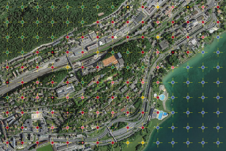
Visuelle Interpretation von in einem regelmässigen Gitter von 100 m angeordneten Stichprobenpunkten auf digitalen Luftbildern an einer photogrammetrischen Auswertungsstation anhand eines standardisierten Nutzungskatalogs.
- Descrizione
-
Hauptgrundlage für die Bestimmung der Bodennutzung sind eingescannte, digitalisierte Luftbilder des Bundesamts für Landestopografie (swisstopo) der Jahre 1979-85, 1992-97 sowie 2004-09. Zur Qualitätssicherung und Erleichterung der Interpretation werden soweit verfügbar Zusatzinformationen, beispielsweise Landeskarten, Stadtpläne, Gebäudeinformationen des Eidg. Gebäude- und Wohnungsregisters, Schutzgebiete, Naturkatastrophen und dergleichen beigezogen. Nach der Luftbildinterpretation werden ausgewählte und besonders schwierig zu beurteilende Gebiete und Stichprobenpunkte im Gelände aufgesucht und verifiziert (Feldbegehungen). Für die Durchführung reliefabhängiger geometrischer Korrekturen kommt das Geländemodell DHM25 von swisstopo zum Einsatz.
- Identificatore del sistema di riferimento
- EPSG:2056
Metadata
- Lingua dei metadati
- Deutsch
- Set dei caratteri dei metadati
- UTF8
- Livello gerarchico
- Set di dati
- Data dei metadati
- 2024-09-05T12:17:11.996Z
- Nome dello Standard dei metadati
-
GM03 2+
Contatto
Servizio responsabile
- Nome dell'ente
-
BFS/OFS GEOSTAT
- Ruolo del responsabile
-
GEOSTAT ist das BFS-Kompetenzzentrum für Geoinformation und digitale Bildverarbeitung.
Indirizzo
- Città
-
Neuchâtel
- Codice postale
-
2010
- Nazione
-
CH
-
geostat@bfs.adm geostat@bfs.admin.ch
- Via
-
Espace de l'Europe
- Numero
-
10
- Casella postale
-
2010
- Risorsa online
- https://www.bfs.admin.ch/bfs/de/home/dienstleistungen/geostat.html ( WWW:LINK )
- Ruolo
- Point of contact
- Frequenza di aggiornamento
- Secondo necessità
- Manutenzione
-
Nachführung erfolgt, wenn Dokumentation fehlerhaft oder verbesserungsbedürftig.