geocat.ch
Swiss land use statistics
The Swiss Land Use Statistic provides detailed and accurate information on the state and evolution of land use and land cover in Switzerland. On this page you will find the geodata of the Land Use Statistics at the hectare level since 1979, as well as documentation on the data and the methodology used to produce these data.
Simple
Identification info
- Alternate title
-
Land use statistics
- Date (Revision)
- 2023-08-30
- Citation identifier
- ch.bfs.arealstatistik
Citation identifier
- Collective title
-
Arealstatistik der Schweiz
- Purpose
-
Detaillierte Erhebung der Bodennutzung und -bedeckung der Schweiz mit dem Ziel, deren Zustand und Entwicklung periodisch auszuweisen.
- Status
- On going
Point of contact
Responsible party
- Organisation name
-
BFS/OFS GEOSTAT
- Position name
-
GEOSTAT is the centre of competence for geoinformation and digital image processing within the Swiss Federal Statistical Office.
Address
- City
-
Neuchâtel
- Postal code
-
2010
- Country
-
CH
- Electronic mail address
-
geostat@bfs.adm geostat@bfs.admin.ch
- Streetname
-
Espace de l'Europe
- Streetnumber
-
10
- Post box
-
2010
- Website
- https://www.bfs.admin.ch/bfs/de/home/dienstleistungen/geostat.html ( WWW:LINK )
- Role
- Point of contact
- Maintenance and update frequency
- As needed
-
GEMET - INSPIRE themes, version 1.0
-
-
Land use
-
Land cover
-
-
GEMET
-
-
vegetation
-
-
geocat.ch
-
-
FSDI Federal Spatial Data Infrastructure
-
opendata.swiss
-
-
GEMET
-
-
aerial photograph
-
-
geocat.ch
-
-
opendata.swiss
-
- Use limitation
-
Freie Nutzung. Quellenangabe ist Pflicht.
- Access constraints
- Intellectual property rights
- Use constraints
- Other restrictions
- Other constraints
- Opendata BY ASK: Open use. Must provide the source. Use for commercial purposes requires permission of the data owner.
- Aggregate Datasetindentifier
- 2da61838-68bf-4a64-9d9f-05236cde1bf1
- Association Type
- Larger work citation
- Distance
- 100 m
- Language
- Deutsch
- Language
- Français
- Language
- Italiano
- Language
- English
- Character set
- UTF8
- Topic category
-
- A Base Maps, Land Cover, Aerial and Satellite Imagery
- A1 Base Maps, Landscape Models
- A2 Land Cover, Land Use
Extent
- Description
-
Switzerland
))

- Supplemental Information
-
Originalresultate aller neueren Arealstatistiken werden bei GEOSTAT in relationalen Datenbanken verwaltet, in welchen jeder Stichprobenpunkt (die für jeden Erhebungszeitpunkt identisch sind) einen Datenrecord darstellt. Für die Diffusion können daraus gleichermassen strukturierte Textdateien (Normalfall), bei Bedarf aber auch GIS-kompatible Vektor- (Punktdaten) oder Rasterdaten (GRID, GeoTIFF) erzeugt werden.
- Basic geodata identifier
-
12.3
- Basic geodata identifier type
- Federal
- Distribution format
-
-
TEXT, semicolon separated (CSV)
()
-
TEXT, semicolon separated (CSV)
()
- OnLine resource
- Preview map.geo.admin.ch ( MAP:Preview )
- OnLine resource
- Geodata (csv) ( WWW:DOWNLOAD-URL )
- OnLine resource
- List of variables ( WWW:DOWNLOAD:TEXT, semicolon separated (CSV) )
- OnLine resource
-
ch.bfs.arealstatistik-bodenbedeckung
(
OGC:WMS
)
WMS-FSDI service, layer "Land use statistics cover"
- OnLine resource
-
ch.bfs.arealstatistik-bodenbedeckung
(
OGC:WMTS
)
WMTS-FSDI service, layer "Land use statistics cover"
- Protocol
-
WWW:DOWNLOAD-URL
- Name of the resource
-
Geodata (csv)
- Function
- Download
- OnLine resource
- Permalink opendata.swiss ( OPENDATA:SWISS )
- OnLine resource
- Data description ( WWW:LINK )
- OnLine resource
-
GEOSTAT
(
CHTOPO:specialised-geoportal
)
GEOSTAT is the centre of competence for geoinformation and digital image processing within the Swiss Federal Statistical Office.
- OnLine resource
- Fachportal: Bodennutzung, -bedeckung ( CHTOPO:specialised-geoportal )
- OnLine resource
-
RESTful API from geo.admin.ch
(
ESRI:REST
)
RESTful API from geo.admin.ch
- Hierarchy level
- Dataset
- Statement
-
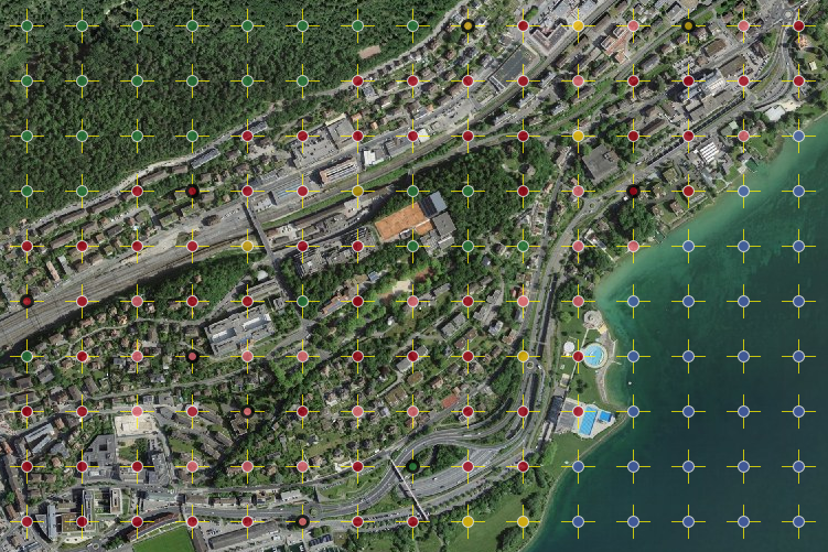
Visuelle Interpretation von in einem regelmässigen Gitter von 100 m angeordneten Stichprobenpunkten auf digitalen Luftbildern an einer photogrammetrischen Auswertungsstation anhand eines standardisierten Nutzungskatalogs.
- Description
-
Hauptgrundlage für die Bestimmung der Bodennutzung sind eingescannte, digitalisierte Luftbilder des Bundesamts für Landestopografie (swisstopo) der Jahre 1979-85, 1992-97 sowie 2004-09. Zur Qualitätssicherung und Erleichterung der Interpretation werden soweit verfügbar Zusatzinformationen, beispielsweise Landeskarten, Stadtpläne, Gebäudeinformationen des Eidg. Gebäude- und Wohnungsregisters, Schutzgebiete, Naturkatastrophen und dergleichen beigezogen. Nach der Luftbildinterpretation werden ausgewählte und besonders schwierig zu beurteilende Gebiete und Stichprobenpunkte im Gelände aufgesucht und verifiziert (Feldbegehungen). Für die Durchführung reliefabhängiger geometrischer Korrekturen kommt das Geländemodell DHM25 von swisstopo zum Einsatz.
- Reference system identifier
- EPSG:2056
Metadata
- Metadata language
- Deutsch
- Character set
- UTF8
- Hierarchy level
- Dataset
- Date stamp
- 2024-09-05T12:17:11.996Z
- Metadata standard name
-
GM03 2+
Metadata author
Responsible party
- Organisation name
-
BFS/OFS GEOSTAT
- Position name
-
GEOSTAT is the centre of competence for geoinformation and digital image processing within the Swiss Federal Statistical Office.
Address
- City
-
Neuchâtel
- Postal code
-
2010
- Country
-
CH
- Electronic mail address
-
geostat@bfs.adm geostat@bfs.admin.ch
- Streetname
-
Espace de l'Europe
- Streetnumber
-
10
- Post box
-
2010
- Website
- https://www.bfs.admin.ch/bfs/de/home/dienstleistungen/geostat.html ( WWW:LINK )
- Role
- Point of contact
- Maintenance and update frequency
- As needed
- Maintenance note
-
Nachführung erfolgt, wenn Dokumentation fehlerhaft oder verbesserungsbedürftig.