geocat.ch
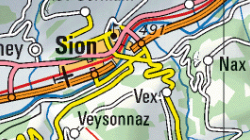
Swiss Map Raster 1:500'000 (VS)
La carte nationale au 1:200’000 est une carte topographique synoptique de la Suisse. La carte-pixel (PK500) est la carte nationale digitalisée, livrable sous forme de données raster géoréférencées (format TIF). Les cartes-pixel sont à dispositions en couleurs combinées (KOMB;508 dpi) ainsi que par couches de couleurs séparées (données binaires 508 dpi). De plus, la version combinaisons de couleurs dans une résolution de 254 dpi contient le relief ombré (KREL).
Simple
Identification info
- Alternate title
-
Swiss Map Raster 500
- Date (Creation)
- 1995-06-30
- Date (Revision)
- 2014-11-30
- Citation identifier
- 160/161/321
Cited responsible party
Responsible party
- Organisation name
-
Federal Office of Topography swisstopo
- Position name
-
Geodata Distribution
- Voice
-
+41 58 469 01 11
- Facsimile
-
+41 58 469 04 59
Address
- City
-
Wabern
- Postal code
-
3084
- Country
-
CH
- Electronic mail address
- Streetname
-
Seftigenstrasse
- Streetnumber
-
264
- Protocol
-
WWW:LINK
- Role
- Custodian
- Last Name
-
geodata
- Organisation Acronym
-
swisstopo
- Purpose
-
fond visuel
- Status
- On going
Point of contact
Responsible party
- Organisation name
-
Federal Office of Topography swisstopo
- Position name
-
Geodata Distribution
- Voice
-
+41 58 469 01 11
- Facsimile
-
+41 58 469 04 59
Address
- City
-
Wabern
- Postal code
-
3084
- Country
-
CH
- Electronic mail address
- Streetname
-
Seftigenstrasse
- Streetnumber
-
264
- Protocol
-
WWW:LINK
- Role
- Custodian
- Last Name
-
geodata
- Organisation Acronym
-
swisstopo
- Maintenance and update frequency
- userDefined
- Maintenance note
-
La mise à jour s’effectue suivant un cycle de 6 ans.
- Name
-
ESRI Enterprise Geodatabase
-
GEMET
-
-
cartography
-
-
geocat.ch
-
-
national map
-
terrain representation
-
-
geocat.ch
-
-
topography
-
-
GEMET
-
-
map chart
-
- Use limitation
-
sous licence
- Access constraints
- Other restrictions
- Other constraints
-
Géodonnées accessibles au public (niveau A selon l'OGéo)
- Other constraints
-
Les conditions générales d'utilisation des géodonnées du Canton du Valais font foi ( https://www.vs.ch/fr/web/guest/information-legale).
- Spatial representation type
- Grid
- Denominator
- 200000
- Language
- Français
- Language
- Deutsch
- Character set
- UTF8
- Topic category
-
- A Base Maps, Land Cover, Aerial and Satellite Imagery
- A1 Base Maps, Landscape Models
- Environment description
-
S:\Géodonnées VS\A1 Cartes de référence\Swiss Map Raster 500 avec relief.lyr S:\Géodonnées VS\A1 Cartes de référence\Swiss Map Raster 500.lyr
Extent
- Description
-
Canton of Valais (VS)
))

- Supplemental Information
-
Etat des mises à jour S:\Géodonnées VS\A1 Cartes de référence\Cartes pixel\Documentation\Nachfuehrungsstand.pdf
- Basic geodata identifier
-
42.5
- Basic geodata identifier type
- Federal
- Geodata Type
- Basic Geodata
- Distribution format
-
-
Tagged Image File Format (TIFF)
()
-
autres formats sur demande / andere Formate auf Anfrage
(
-
)
-
Tagged Image File Format (TIFF)
()
Distributor contact
Responsible party
- Organisation name
-
Kanton Wallis - Dienststelle für Geoinformation (DGI) - CC GEO
- Position name
-
CC GEO
- Voice
-
+41 27 606 28 00
Address
- City
-
Sion
- Postal code
-
1950
- Country
-
CH
- Electronic mail address
-
sitvs@admin.vs sitvs@admin.vs.ch
- Streetname
-
Rue du Scex
- Streetnumber
-
4
- Protocol
-
WWW:LINK
- Role
- Distributor
- Organisation Acronym
-
Dienststelle für Geoinformation (DGI)
- Hierarchy level
- Dataset
- Statement
-
Se base sur la Mensuration
- Reference system identifier
- EPSG:2056 / CH1903+_MN95
Metadata
- Metadata language
- Français
- Character set
- UTF8
- Hierarchy level
- Dataset
- Date stamp
- 2024-02-16T07:01:01.625Z
- Metadata standard name
-
GM03 2+
Metadata author
Responsible party
- Organisation name
-
Kanton Wallis - Dienststelle für Geoinformation (DGI) - CC GEO
- Position name
-
CC GEO
- Voice
-
+41 27 606 28 00
Address
- City
-
Sion
- Postal code
-
1950
- Country
-
CH
- Electronic mail address
-
sitvs@admin.vs sitvs@admin.vs.ch
- Streetname
-
Rue du Scex
- Streetnumber
-
4
- Protocol
-
WWW:LINK
- Role
- Distributor
- Organisation Acronym
-
Dienststelle für Geoinformation (DGI)