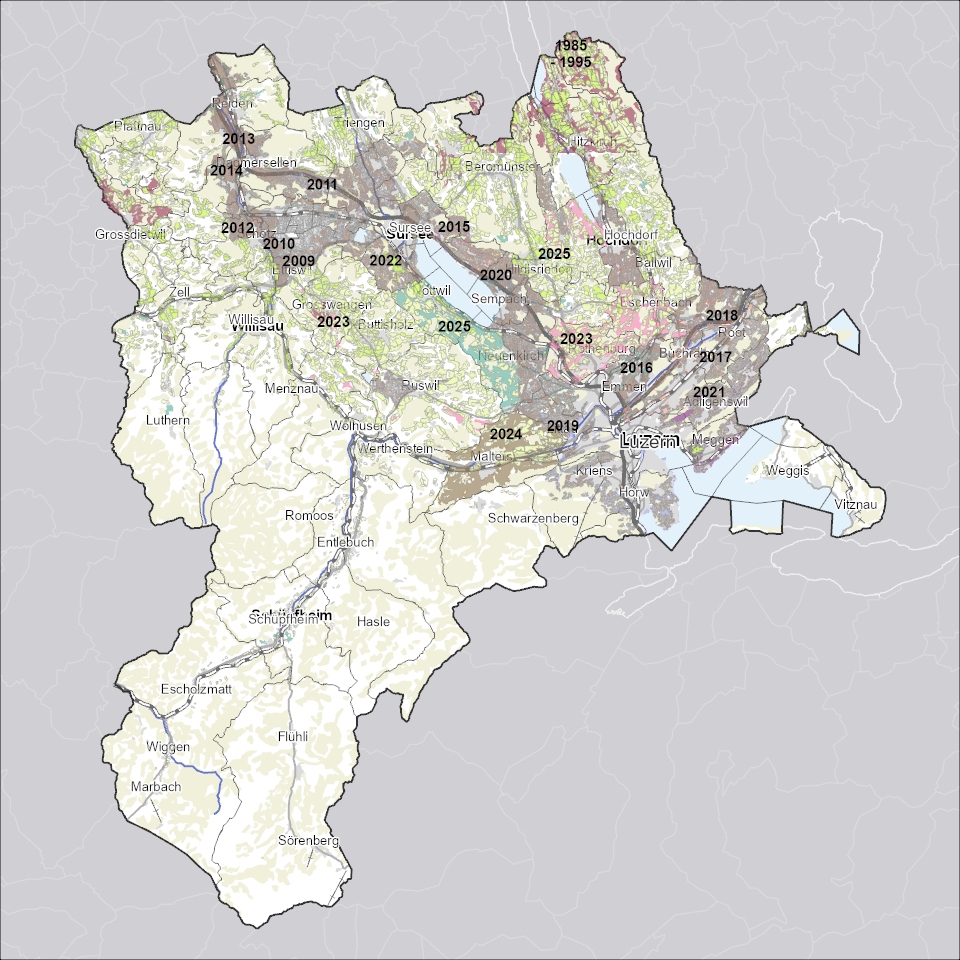
Fruchtfolgeflächen
Zeigt für die landwirtschaftliche Nutzung besonders gut geeignetes, ackerfähiges Kulturland.
Simple
Informazioni di identificazione
- Titolo alternativo
-
FFFXXXXX_COL
- Data (Creazione)
- 2024-07-09
- Formato di presentazione
- Mappa digitale
- Finalità
-
Fruchtfolgeflächen (FFF) sind für die landwirtschaftliche Nutzung besonders gut geeignetes, ackerfähiges Kulturland. Sachplan Fruchtfolgeflächen des Bundes (SP FFF)Der Sachplan Fruchtfolgeflächen des Bundes legt den Mindestumfang an Fruchtfolgeflächen für die gesamte Schweiz und die Aufteilung auf die Kantone fest. Die Kantone müssen dafür sorgen, dass dieser Mindestumfang dauernd erhalten bleibt (Art. 30 Abs. 1 und 2 RPV). Für die Schweiz ist eine Mindestfläche von 438`560 Hektaren definiert. Davon muss der Kanton Luzern 6%, das heisst eine Fläche von 27`500 Hektaren sicherstellen. Der SP FFF bezweckt die Ernährungssicherung in Zeiten von ungenügender Versorgung, den Erhalt der natürlichen Ernährungsgrundlage und des Produktionspotenzials für die kommenden Generationen und sorgt für den Schutz des Kulturlandes.
- Status
- In corso
Punto di contatto
Servizio responsabile
- Nome dell'ente
-
Kanton Luzern, Abteilung Geoinformation
- Telefono
-
041 228 51 83
Indirizzo
- Risorsa online
- https://geoportal.lu.ch/ ( https )
- Ruolo
- Publisher
Punto di contatto
Servizio responsabile
- Nome dell'ente
-
Dienststelle Umwelt und Energie (uwe)
- Telefono
-
041 228 60 60
Indirizzo
- Risorsa online
- https://uwe.lu.ch/ ( https )
- Ruolo
- Owner
- Cognome
-
Dienststelle Umwelt und Energie (uwe)
- Abbreviazione dell'organizzazione
-
uwe
- Frequenza di aggiornamento
- Secondo necessità
-
geocat.ch
-
-
opendata.swiss
-
Boden
-
Bodennutzung
-
Fruchtfolgefläche
-
Landwirtschaft
-
Landwirtschaftliche Nutzung
-
Raumplanung
-
- Vincoli di accesso
- none
- Vincoli di fruibilità
- Proprietà intellettuale dei dati
- Limitazione d’uso
-
öffentlich zugängliche Geobasisdaten
- Vincoli di accesso
- none
- Vincoli di fruibilità
- none
- Limitazione d’uso
-
Freie Nutzung. Quellenangabe ist Pflicht
- Identificatore aggregato del dataset
- 33c09168-8525-4176-9734-4f295d7e6ffe
- Tipo di associazione
- Larger work citation
- Tipo di rappresentazione spaziale
- undefined
- Lingua dei metadati
- Deutsch
- Set dei caratteri dei metadati
- UTF8
- Tema
-
- S Agricoltura
- Descrizione
-
Kanton Luzern
))
- Formato di distribuzione
-
-
ESRI Geodatabase (.gdb)
(
)
-
ESRI Shapefile (.shp)
(
)
-
OGC GeoPackage (.gpkg)
(
)
-
ESRI Geodatabase (.gdb)
(
)
Distributore
Servizio responsabile
- Nome dell'ente
-
Dienststelle Raum und Wirtschaft (rawi)
- Telefono
-
041 228 51 83
Indirizzo
- Risorsa online
- https://geoportal.lu.ch ( https )
- Ruolo
- Point of contact
- Nome
-
Geodaten
- Cognome
-
Kanton Luzern
- Abbreviazione dell'organizzazione
-
rawi
- Risorsa online
-
Datenshop
(
https
)
Produktansicht Geodatenshop
- Livello
- Set di dati
- Genealogia del dato – Processo di produzione
-
unbekannt
- Identificatore del sistema di riferimento
- CH1903+
Metadata
- Lingua dei metadati
- Deutsch
- Set dei caratteri dei metadati
- UTF8
- Livello gerarchico
- Set di dati
- Data dei metadati
- 2024-12-05
- Nome dello Standard dei metadati
-
GM03 2+
Contatto
Servizio responsabile
- Nome dell'ente
-
Dienststelle Raum und Wirtschaft (rawi)
- Telefono
-
041 228 51 83
Indirizzo
- Città
-
Luzern
- Codice postale
-
6002
- Nazione
-
CH
- Via
-
Murbacherstrasse
- Numero
-
21
- Risorsa online
- https://geoportal.lu.ch ( https )
- Ruolo
- Point of contact
- Nome
-
Philipp
- Cognome
-
Renggli
- Abbreviazione dell'organizzazione
-
rawi
- Frequenza di aggiornamento
- Secondo necessità
 geocat.ch

