geocat.ch
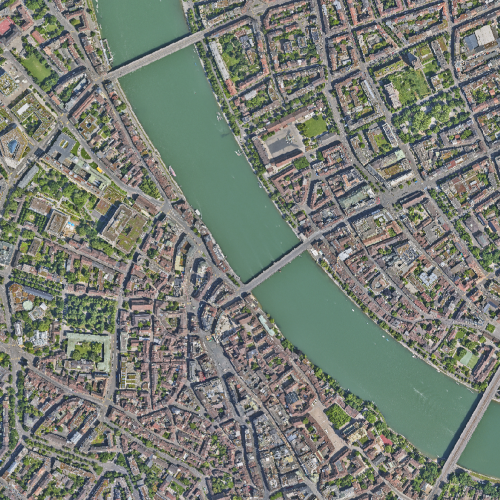
Orthofotos
Entzerrte und georeferenzierte digitale Luftbilder von verschiedenen Jahren und Jahreszeiten in TrueColor.
Simple
Identification info
- Date (Creation)
- 1999-01-01
Cited responsible party
Responsible party
- Organisation name
-
Kanton Basel-Stadt
- Position name
-
Bau- und Verkehrsdepartement
- Voice
-
+41 (0)61 267 92 85
Address
- City
-
Basel
- Postal code
-
4052
- Country
-
CH
- Electronic mail address
- Streetname
-
Dufourstrasse
- Streetnumber
-
40/50
- Protocol
-
WWW:LINK
- Role
- Author
- First Name
-
Grundbuch- und Vermessungsamt
- Last Name
-
Amtliche Vermessung
- Organisation Acronym
-
BS-BVD-GVA-AV
- Collective title
-
Orthofotos
- Purpose
-
Orthofotos können für Nachführungen und Auswertungen (Metoewasser, Dachlandschaften etc.) verwendet werden. Ebenso ist eine historische Chronologie möglich. Überlagerungen mit amtlichen oder historischen Vektordaten sind möglich.
- Status
- Completed
Point of contact
Responsible party
- Organisation name
-
Kanton Basel-Stadt
- Position name
-
Bau- und Verkehrsdepartement
- Voice
-
+41 (0)61 267 92 85
Address
- City
-
Basel
- Postal code
-
4052
- Country
-
CH
- Electronic mail address
- Streetname
-
Dufourstrasse
- Streetnumber
-
40/50
- Protocol
-
WWW:LINK
- Role
- Owner
- First Name
-
Grundbuch- und Vermessungsamt
- Last Name
-
Amtliche Vermessung
- Organisation Acronym
-
BS-BVD-GVA-AV
- Maintenance and update frequency
- userDefined
-
GEMET - INSPIRE themes, version 1.0
-
-
Orthoimagery
-
-
GEMET
-
-
aerial photograph
-
-
geocat.ch
-
-
opendata.swiss
-
- Other constraints
-
Die Geodaten sind öffentlich zugänglich. (Zugangsberechtigungsstufe [A] = öffentlich)
- Other constraints
-
Es gelten die Nutzungsbedingungen für Geodaten des Kantons Basel-Stadt. ( http://www.geo.bs.ch/agb)
- Spatial representation type
- Grid
- Language
- Deutsch
- Character set
- UTF8
- Topic category
-
- A Base Maps, Land Cover, Aerial and Satellite Imagery
- A1 Base Maps, Landscape Models
- A3 Aerial and Satellite Imagery
Extent
- Description
-
Basel-Stadt und Umgebung
))

- Geographic identifier
- Basel-Stadt (und Umgebung)
- Basic geodata identifier
-
10-BS
- Basic geodata identifier type
- Cantonal
- Geodata Type
- Open Data
- Distribution format
-
-
Tagged Image File Format (TIFF)
()
-
JPEG (JPG)
()
-
Tagged Image File Format (TIFF)
()
Distributor contact
Responsible party
- Organisation name
-
Kanton Basel-Stadt
- Position name
-
Bau- und Verkehrsdepartement
- Voice
-
+41 (0)61 267 92 85
Address
- City
-
Basel
- Postal code
-
4052
- Country
-
CH
- Electronic mail address
- Streetname
-
Dufourstrasse
- Streetnumber
-
40/50
- Protocol
-
WWW:LINK
- Hours of service
-
Mo - Do: 8:00 bis 12:00, 13:30 bis 16:30, Fr: 8:00 bis 12:00, 13:30 bis 16:00
- Role
- Distributor
- First Name
-
Grundbuch- und Vermessungsamt
- Organisation Acronym
-
BS-BVD-GVA-KZ
- OnLine resource
-
MapBS
(
CHTOPO:specialised-geoportal
)
Öffentliches Auskunftssystem des Kantons Basel-Stadt
- OnLine resource
-
Geodaten-Shop
(
WWW:DOWNLOAD-APP
)
Öffentlich zugänglicher Geodaten-Downloaddienst des Kantons Basel-Stadt
- OnLine resource
-
WMS BS
(
OGC:WMS
)
Die derzeit im WMS BS verfügbaren Datenebenen entsprechen, bis auf wenige Ausnahmen, den Geodaten, welche auch in MapBS dargestellt sind. Der WMS BS ist kostenlos nutzbar und bietet Zugriff auf öffentliche sowie beschränkt öffentliche Geodaten, wobei gegebenenfalls Benutzername und Passwort benötigt werden (Zugangsdaten von MapBS).
- OnLine resource
-
Permalink opendata.swiss
(
OPENDATA:SWISS
)
Permalink opendata.swiss
- Reference system identifier
- CH1903+ / LV95 / EPSG: 2056
Metadata
- Metadata language
- Deutsch
- Character set
- UTF8
- Hierarchy level
- Dataset
- Date stamp
- 2023-11-28T13:30:17.489Z
- Metadata standard name
-
GM03 Basel-Stadt
- Metadata standard version
-
2.0
Metadata author
Responsible party
- Organisation name
-
Kanton Basel-Stadt
- Position name
-
Bau- und Verkehrsdepartement
- Voice
-
+41 (0)61 267 92 85
Address
- City
-
Basel
- Postal code
-
4052
- Country
-
CH
- Electronic mail address
- Streetname
-
Dufourstrasse
- Streetnumber
-
40/50
- Protocol
-
WWW:LINK
- Role
- Custodian
- First Name
-
Grundbuch- und Vermessungsamt
- Last Name
-
Fachstelle für Geoinformation
- Organisation Acronym
-
BS-BVD-GVA-FGI